Planning application drawings are a key part of submitting a planning application in England. They provide the local planning authority with the visual and technical information needed to understand a proposed development, assess its impact and decide whether planning permission should be granted.
Whether you are planning a house extension, converting a building, constructing a new property or changing the use of land, the drawings you submit must clearly explain what you intend to do.
The exact requirements depend on the type of application, the development site and the local planning authority’s validation requirements. Preparing the correct drawings before submission can help prevent avoidable delays and make your proposal easier to assess.
This article explains which planning application drawings you may need, how they should be prepared and what to check before submitting your application.
What Are Planning Application Drawings?
Planning application drawings are plans and technical illustrations submitted to a local planning authority to describe a proposed development.
They typically show the site’s location, the existing property or land, the proposed changes and how the development relates to its surroundings.
The drawings allow planning officers to assess matters such as the scale and appearance of a building, its position on the site, its relationship with neighbouring properties and the effect of the proposal on the surrounding area.
According to GOV.UK’s guidance on making a planning application, applications must include plans and drawings. Additional drawings will generally be necessary to describe the development, depending on the proposal and applicable local requirements.
Which Drawings Are Required for a Planning Application?
There is no universal drawing package suitable for every development. The documents required will depend on what you are applying to do and the information the planning authority needs to assess it.
The following are common types of planning application drawings.
1. Location Plan
A location plan shows the application site in relation to the surrounding area. It helps the local planning authority identify the property or land and understand its position within the wider neighbourhood.
A location plan should generally:
- Be based on an up-to-date map.
- Show sufficient surrounding roads, buildings and features to identify the site.
- Mark the application site’s boundary clearly with a red line.
- Include all land necessary to carry out the proposed development.
- Identify other relevant land owned by the applicant using a blue line where applicable.
The typical scale is 1:1,250 or 1:2,500, depending on the site and circumstances.
An accurate location plan is essential because the authority needs to know precisely which land the application covers.
2. Site Plan or Block Plan
A site plan, also known as a block plan, provides a more detailed view of the application site.
It shows the proposed development in relation to the site’s boundaries and existing features. Depending on the project, it may include buildings, extensions, access routes, parking, landscaping and neighbouring streets.
A site plan is particularly important when assessing how a proposed extension or new building will fit within the available space.
Scales of 1:200 or 1:500 are commonly used, although the appropriate scale depends on the size and nature of the development.
The location plan and site plan serve different purposes: the location plan establishes where the site is, while the site plan explains the layout and proposed development in greater detail.
3. Existing and Proposed Floor Plans
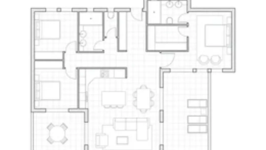
Floor plans show the internal layout of a building from above.
Existing floor plans show the current arrangement, while proposed floor plans demonstrate how the building will look after the development.
For an extension or conversion, these drawings may show room layouts, walls, doors, windows, circulation areas and the extent of the proposed changes.
They should be clearly labelled so the planning officer can distinguish between existing and proposed arrangements.
Scales of 1:50 or 1:100 are commonly used. The drawings should provide enough detail to understand the proposal without becoming difficult to read.
4. Existing and Proposed Elevations
Elevation drawings show the external faces of a building.
They help the local planning authority understand its height, appearance, roof shape, windows, doors, materials and other visible features.
Where a building is being altered, existing and proposed elevations help demonstrate exactly what will change.
For example, a proposed rear extension may require elevation drawings showing its height, roof design, external materials and relationship with the existing house.
The appropriate scale is commonly 1:50 or 1:100, depending on the project and local requirements.
5. Roof Plans
Roof plans show the shape and arrangement of a roof when viewed from above.
They may be needed when a proposal involves a loft conversion, dormer window, roof extension, rooflights or changes to the roof’s overall appearance.
Where roof alterations are proposed, existing and proposed roof plans can help demonstrate the extent of the changes.
6. Section Drawings
Section drawings show a building or site as though it has been cut through vertically.
They can illustrate floor levels, building heights, roof profiles, ground levels and the relationship between the proposed development and surrounding properties.
Sections are especially useful on sloping sites or where changes in ground levels could affect neighbouring land or buildings.
Depending on the proposal, the local planning authority may also request site-level information or a topographical survey.
7. Street Scene and Context Drawings
Some developments require drawings that show how the proposal relates to nearby buildings and the wider streetscape.
These can be particularly useful where a proposed building is significantly taller or larger than its neighbours, or where its appearance will noticeably affect the surrounding area.
The need for context drawings depends on the development and the local planning authority’s requirements.
What Scale Should Planning Application Drawings Use?
Planning application drawings must identify their scale clearly. Common examples include:
| Drawing type | Typical scale |
| Location plan | 1:1,250 or 1:2,500 |
| Site or block plan | 1:200 or 1:500 |
| Floor plans | 1:50 or 1:100 |
| Elevations | 1:50 or 1:100 |
| Roof plans | 1:50 or 1:100 |
| Building sections | 1:50 or 1:100 |
| Site sections and levels | 1:200 or 1:500 |
These are typical scales, not a definitive list of requirements for every application. Always check the relevant local planning authority’s validation checklist before preparing your final drawings.
The Planning Portal’s plans and drawings guidance explains the purpose and common requirements of the different drawing types.
What Makes Planning Application Drawings Acceptable?
Drawings must be clear enough for the local planning authority to understand the development and determine whether the application contains the required information.
Before submission, check that your drawings:
- Have clear titles and drawing reference numbers.
- Identify the scale and original paper size.
- Include a scale bar where appropriate.
- Show the north direction on plans where required.
- Use consistent dimensions and measurements.
- Clearly distinguish existing features from proposed changes.
- Include relevant site boundaries and neighbouring features.
- Match the information provided in the application form.
- Are legible when viewed electronically.
- Use consistent drawing references and revision details.
The Planning Portal recommends including a scale bar, key dimensions, north direction, original paper size and scale on drawings to help local authorities review submissions efficiently.
Drawings should also be internally consistent. For example, an extension shown on the proposed floor plan should match the relevant site plan and elevations.
Can You Draw Your Own Planning Application Drawings?
Whether you can prepare your own drawings depends on the project and the level of detail required.
For a simple proposal, you may be able to prepare drawings yourself if you have the necessary skills and can meet the applicable requirements. However, freehand sketches or informal illustrations will not necessarily be suitable for a formal planning application.
More complex projects may require an experienced architectural designer, architect or other suitably qualified professional to prepare accurate drawings.
The important consideration is whether the drawings communicate the proposed development clearly and satisfy the local planning authority’s requirements.
Planning Build offers architectural design services to support projects that require professional design input alongside planning advice.
Common Mistakes to Avoid
Errors in planning application drawings can create additional work or prevent an application from being validated.
Common problems include:
Submitting incomplete drawings. A proposal may require existing and proposed plans, elevations or additional information that has not been included.
Using inconsistent dimensions. Measurements and building positions should agree across all relevant drawings.
Marking the site boundary incorrectly. The location plan should identify the land covered by the application accurately.
Using unclear scales or labels. Drawings should be legible and clearly identify what each plan represents.
Ignoring local validation requirements. Some authorities require additional drawings or supporting documents for particular developments.
Submitting outdated plans. Drawings should reflect the actual proposal being submitted, including any design changes made before submission.
Checking these details before submitting the application can help reduce avoidable validation queries.
Planning Application Drawings and Building Regulations Drawings
Planning application drawings and Building Regulations drawings are not interchangeable.
Planning application drawings explain the proposed development so the local planning authority can assess its planning implications, including its appearance, scale, layout and relationship with its surroundings.
Building Regulations drawings focus on technical construction requirements, such as structural safety, insulation, fire safety and drainage.
Depending on the project, you may need planning permission and separate Building Regulations approval. You can learn more about the latter through Planning Build’s Building Regulations compliance service.
Get Your Planning Application Drawings Ready
Planning application drawings help turn a development idea into a proposal that the local planning authority can assess.
The drawings required will depend on your project, but may include a location plan, site plan, existing and proposed floor plans, elevations, roof plans and sections.
Preparing accurate, consistent drawings and checking the local authority’s validation requirements before submission can help avoid unnecessary complications.
Planning Build can support you with planning advice, architectural design and the preparation of your application. If you are unsure which drawings your project requires, contact Planning Build to discuss your proposal and the support you may need.